Vision
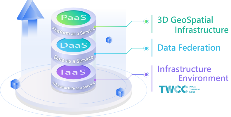
Based on the program on building national backbone network and high-performance computing environment, the National Center for High-performance Computing combines existing research capabilities and large-scale host deployment experience to build a 3D spatial information infrastructure. It continues to introduce DataCube technology to cultivate the spatial Data federation system, aiming to deploy on demand, link spatial data, and achieve the synergy of digital twins and cross-domain data governance for public departments.

Services
3D Geospatial Infrastructure

Enhancing the 3D GIS infrastructure for collaboration and analysis tool sharing, reducing the construction time of GIS systems in public departments, and accelerating application service expansion.
Data Federation

National grid spatial data federation supporting international standard services, multi-dimensional array of remote sensing images, meteorology, terrain, UAVs, seamless vertical integration, connecting environmental observation/simulation data, introducing Data Federation technology, and adopting OGC standards to create data added value.
Features
- Deployment on Demand
- Providing virtualization technology that connects to the world, and quickly deploying a 3D GIS development environment.
- Data Federation
- Pioneering domestic data reciprocity federation, integrating across units and fields.
- Common Module
- Continuing to create common modules and enhance application service solutions.
- High-performance Cloud
- Experience unrestricted cloud space and create a new spatial information cloud platform as a service architecture.
- Flexible Solutions
- Providing different host and system solutions according to requirements, meeting different usage purposes, and allowing for customized functions.
History
- 2025
-
2025/08/03~2025/08/08
Participated in IEEE IGARSS 2025 to exchange on the GDXP platform and technical architecture
-
2025/07/10
Participated in the TGIS 3D Co-Construction and Data Federation Technology Forum
- 2024
-
2024/11/04~2024/11/08
2024 130th OGC Member Meeting
-
2024/11/01
Spatial Information Digital Twin and Data Cube Technology Forum
-
2024/10/23
Data Federation and Image Analysis Applications
- 2023
-
2023/10/25
2023 3D GeoSpatial Infrastructure and Data Federation Application Workshop
-
2023/06/29
2023 TGIS-3D Spatial Information Collaboration Data Federation Technology Forum
-
2023/07/16~2023/07/21
Participated in IEEE IGARSS to promote the GDXP platform and architecture
- 2022
-
2022/10/19
2022 3D Spatial Information Infrastructure Collaboration and Data Federation Application Seminar
-
2022/08/18 , 2022/08/25
2022 3D GeoSpatial Infrastructure and Data Federation Basic Application Service Workshop
-
2022/04/25
Cooperating with Nantou County Government on Multi-dimensional Map Data Storage Issues
-
2022/03/22
Participated in the 2022 Smart City Expo
-
2022/03/16
Keelung City Government Cooperation in Land Information Issues
-
2022/03/14
Tainan City Government Cooperation in Underground Pipeline Issues
- 2021
-
2021/10/06
3D Spatial Information Infrastructure Collaboration and Data Federation Application Results Presentation
-
2021/09/17
GeoSpatial Festival - Datacube Forum
-
2021/09/09
Second Expert Seminar Discussing the Challenges of 3D GeoSpatial Infrastructure
-
2021/07/01
The Agriculture Council and the Kaohsiung Agriculture Bureau jointly introduced aerial image data sharing and Federation
-
2021/06/30
Expert Seminar Discussing the Goals of 3D GeoSpatial Infrastructure
-
2021/06/23
Signed a bilateral cooperation agreement with the Taichung Water Resources Bureau
-
2021/06/17
Participated in OGC Asia Forum Presented NCHC's 3D Spatial Information Collaboration
-
2021/03
OGC TC Initiated Domestic Data Sharing and Federation Concept
- 2018
-
2018/11/21
Dr. Peter Baumann from German, OGC WCS Chair, visited NCHC

